Howdy, Stranger!
It looks like you're new here. If you want to get involved, click one of these buttons!
Categories
- 2.1K All Categories
- 202 Site Announcements
- 68 News and Announcements
- 134 General Discussion
- 853 Fractal Mapper
- 220 Fractal Mapper General
- 627 Maps and Symbols
- 33 Skwyre Virtual Table Top
- 30 Skwyre General Discussion
- 3 Skwyre How-To
- 377 AstroSynthesis
- 282 AstroSynthesis General
- 95 AstroSynthesis Plug-ins and Scripts
- 107 The Keep
- 107 The Keep General
- 59 ScreenMonkey General
- 18 ScreenMonkey Setup and Configuration
- 332 Inspiration Pad Pro
- 332 Inspiration Pad Pro General
- 135 NBOS Character Sheet Designer
- 135 Character Sheet Designer General
Jörðgarð Map No. 496 - Darkmill Village

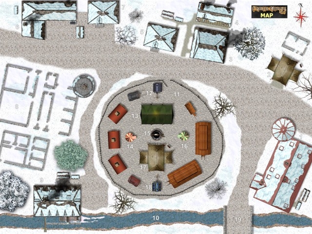
Jörðgarð Map No. 496 is from the forthcoming Jörðgarð Trails adventure Trailsend. The PCs reach the evilly-aligned, snowy village of Darkmill. To their surprise, they see what looks like a ring of carnival wagons on the village circle. To their greater surprise, they notice that the village circle is free of any trace of winter.
Key to the village map:
New Castle. This has served since the move of the baronial seat as the barracks for the four human and two orc members of the crimson militia stationed in the village. However, it appears to be vacant.
The Carnival's Temporary Animal Tent.
Tavernkeep Valbjörn's Easteye Tavern.
Valbjörn's Brewhouse.
Valbjörn's Barn. In individual stalls, it houses a cow, four pigs and a dozen chickens.
Ingvar's Smithy. This is the farmhouse of master smith Ingvar and his wife þórsteina. The smithy is in the right-hand part of the building, behind the coal bin. Ingvar only occasionally gets work as a smith.
Ingvar's Barn.
The Old Castle foundation stones.
Village Grainmill. The mill is owned by the duchy. The miller, Knútar, and his wife, Áslaugur, live in the mill building.
Viður River.
Market Circle.
Carnival Master Hafsteinn's Wagon.
Women's Tent.
Bjargþor's Fortune-Telling Tent.
Village Well.
Friðjóna's Fortune-Telling Tent
Men's Tent. The tent has two wings. In the left or west wing, Valbjörn's sister Bjarnrún and later in the evening Valbjörn hand out free tankards of beer. Hafsteinn has paid for the beer. In the right or east wing, the farm couple Nils and his wife, Ylva, hand out free bread slices with cold cuts and butter. From where the bread, sausage and butter come is unknown.
Sædis' Wagon.
Bridge to the South Farms and Fields.
Other Locations: There are 37 other farms beyond the map to the north and south, and the farm fields are beyond them. There also are six more farms beyond the map along the main road to the left or west.
The map is available in two versions:
- As a JPG flat map of 2048 x 1535 Pixels, 1,3 kb, available from the NBOS website at:
https://www.nbos.com/nox/download/1087.
- Fully editable in the FMP format of FM8 (23,5 MB), here:
https://www.vintyri.org/joerdhgardh/mapdownloads_44.htm
Both versions are released for free personal and commercial use under the Open Game License Version 1.0a, which you can read on the Jörðgarð website at:
https://vintyri.org/joerdhgardh/
Next: Easteye Tavern